Entry Nº 013
Costa Rica property size: when registry, survey plan and cadastral map disagree
A Costa Rican property can have three area measurements: registry, survey plan and cadastral map. Where the map is official, the law presumes it correct; a gap is fixed by deed or in court.
PropScan's sample property, a concession in the maritime zone at Playa Las Manchas in Montezuma, has three measurements. Its registry record says 23,902.95 m². Its plano catastrado, the registered survey plan, says the same. The Registro Nacional keeps its own map of the country's parcels, the cadastral map, and it draws this one at 23,401.11 m², about 500 m² or 2.1% less.[1] The map raises no warning about the difference.[2]
The parcel is in Cóbano, where the map became official in October 2025. Since then, the law presumes the map's location and measurement correct, and only a court can overturn them.[3] Across the country, the Registro's map marks about one parcel in four as inconsistent with the registry in some way.[4]
Key points
- Every entry recorded against a Costa Rican property must cite a registered survey plan, the plano catastrado. A plan that was never registered has no legal effect.
- The registry record, the surveyor's plan and the Registro's map can each give a different area. Half the parcels on the map rest on a plan surveyed in 2003 or earlier.
- Once a district is declared a zona catastrada, the map's location and measurement are presumed correct and can be challenged only in court. By April 2026, 487 of the country's 492 districts had been declared, 162 of them that year.
- Since March 2025, a newly registered plan lapses after one year unless a registry entry cites it.
- An owner can raise the recorded area by up to 10% with a statement in a public deed. In a sale at a total price, the price changes only when the area is off by at least 10%.
What a cadastral plan is, and why every sale cites one
A surveyor draws a plano de agrimensura: the property's shape, boundaries, area and neighbors, placed on national coordinates. It becomes a plano catastrado once the Catastro Nacional, the national cadastre, registers it. The Catastro is part of the Registro Nacional's property registry, the Registro Inmobiliario.[5]
Every entry recorded against a property, such as a sale, a split or a merger, must cite a registered plan. Only three entries are exempt: canceling a mortgage, protecting a family home and recording a court attachment. A plan that was never registered has no legal effect.[6] The registry record, the folio real, gives the plan's number on its Plano line, next to the area written out in words on the Mide line. The title search article shows where to find both.
The surveyor vouches for the plan's coordinates, area and location, except where they contradict the cadastral map or a plan already cited in the registry.[7] A plan does not prove ownership. Registering one does not make a void document valid or cure its defects.[8]
Three areas for one property, and why they differ
Each of the three numbers comes from a different place:
| Source | What it is | Where its area comes from |
|---|---|---|
| Registry record (folio real) | The property's entry in the Registro Nacional, with the area written out on its Mide line | Copied from the documents filed for the property over the years |
| Survey plan (plano catastrado) | A drawing of this one property by a licensed surveyor, registered with the Catastro | The surveyor's measurement of the land |
| Cadastral map (mapa catastral) | The Registro's own map of the country's parcels, about 2.1 million of them[4] | Calculated from the parcel's outline, which the Registro drew from aerial photographs taken in 2005 to 2007 and from its own registry and plan entries[9] |
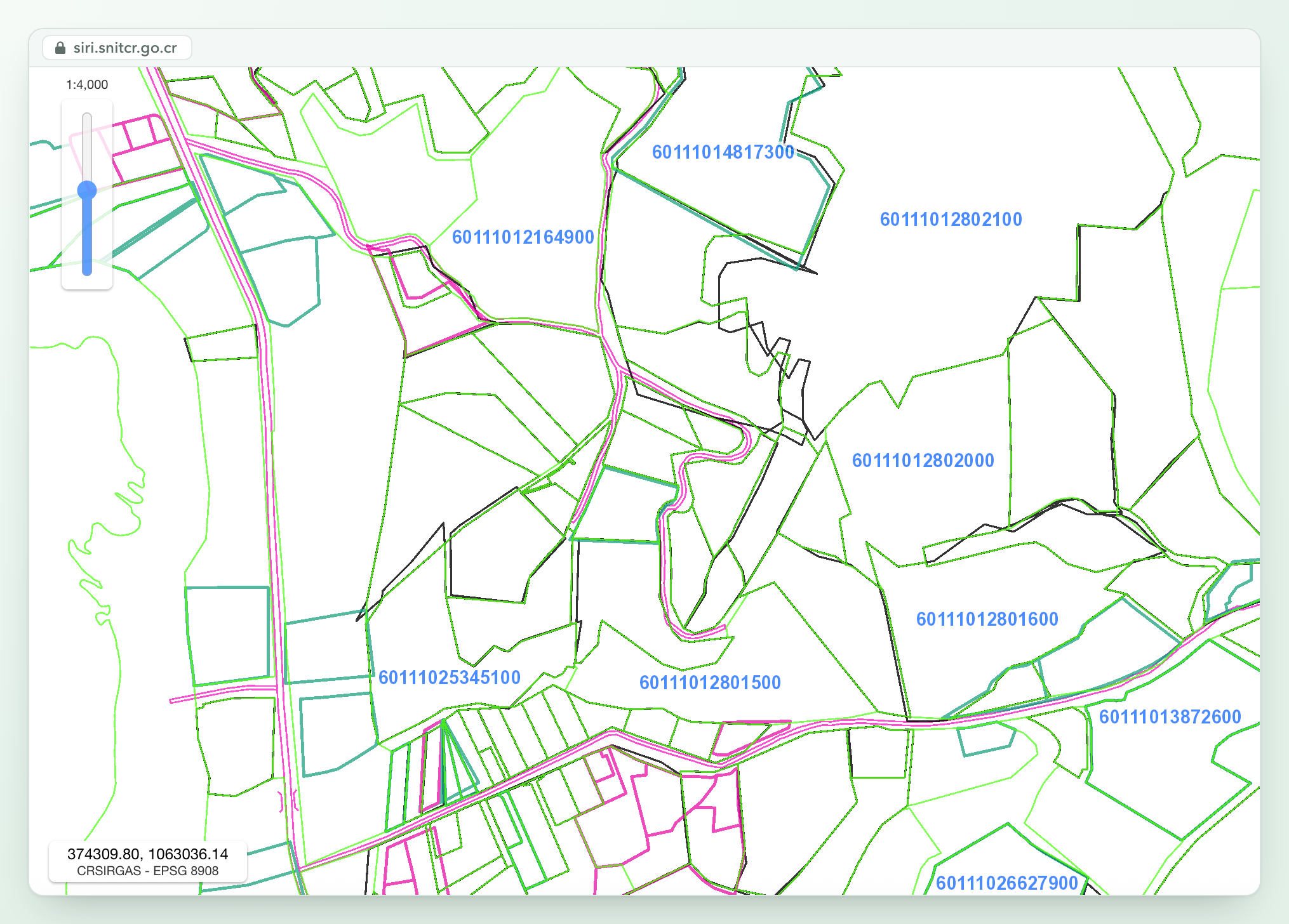
Part of the cadastral map in Cóbano, the sample property's district, in the Registro's SIRI viewer at 1:4,000. The blue numbers label parcels. Outlines from different layers don't always line up.
Many plans are old. Half the parcels on the map rest on a plan from 2003 or earlier, and 41% on one from before 2000.[4]
The map has its own tolerance. A boundary on it may sit up to 0.85 meters from its true position where the map was drawn at a scale of 1:1,000, the standard for parcels of 5,000 m² or less, and up to 4.25 meters at 1:5,000.[10] The sample property's boundary runs 874 meters, so moving it 60 centimeters inward all the way around would take about 500 m² off its area.
The Registro flags parcels on the map that it finds inconsistent with the registry. On the June 2026 map, about one parcel in four carried at least one such flag, and two in three were marked compatible with the registry.[4] The Registro does not publish what each flag means. A parcel with no flag can still differ in area, as the sample property does.
Zona catastrada: when the map becomes the official measurement
The cadastre is built district by district. While the survey is under way, the district is a zona catastral. When the survey is finished and made official, a decree declares it a zona catastrada.[11] From then on, the map's location and measurement of each parcel are presumed correct and can be challenged only in court. The Catastro can still correct its data, on its own or at an owner's request backed by a licensed professional.[3]
Before the decree, the Catastro shows the survey's results at a public exhibition. Owners have 15 days after it closes to object in writing. An owner who does not come is taken as agreeing, and the law makes no exception for owners living abroad.[12]
The exhibition can come years before the decree. In Cóbano it ran from December 9 to 16, 2021, and the decree took effect on October 29, 2025.[13] In Nosara it ran from February 6 to 13, 2018, and the decree was published on April 28, 2026.[14]
By April 2026, decrees had declared 487 of the country's 492 districts, about 99% of its land. Five were left: Legua in Aserrí, San Juan de Mata in Turrubares, San Lorenzo in San Ramón, Macacona in Esparza and Naranjito in Quepos.[15]
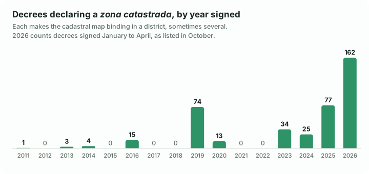
Decrees as listed in SINALEVI, the attorney general's legal database, in October 2026. Some decrees cover more than one district. Source: reference [15].
In a zona catastrada, the notary needs a certificado catastral for any deed that transfers or changes a property. The certificate is valid for one month.[16]
Plans now expire unless a registry entry cites them
Since March 25, 2025, every newly registered plan is provisional. It lapses by law after a year unless it is used in a registry entry, such as a sale or a split. Some plans get three years: those for a possession claim (an información posesoria), for usucapión (ownership acquired through long possession) and for a concession. Since June 2026, plans for condominium units and urbanization lots last five.[17] Older plans that no registry entry had cited were canceled by law around March 2026.[18]
If a seller shows you a recent survey that no registry entry cites, it may already have lapsed. The plan that counts is the one the registry record cites, or a new one the sale itself will record.
A plan that splits a lot off a larger property needs the municipality's approval, its visado, before the Catastro will register it.[19] The zoning article explains what the municipality checks.
Two registered plans can also cover the same ground. The Catastro registers a new plan even when it contradicts older ones, as long as it corrects an error in the survey, the location or the registry data.[20] Neither plan transfers ownership. In a zona catastrada, neighbors whose plans conflict settle the boundary with the Catastro as arbiter, and the owner of the wrong plan pays the costs.[6]
How to check the plan and settle a gap before you buy
- Get the plan the record cites. A certified copy of the plan costs ₡2,925. In a zona catastrada, the certificado catastral costs ₡8,495; each carries ₡5 more for the Archivo Nacional. The certificate shows the parcel's drawing and data from the map and is valid for a month.[21]
- Compare the three areas: the Mide line, the plan's total area and the map. The Registro's public map viewer, SIRI (the Sistema de Información Registro Inmobiliario), shows the cadastral map without an account and has a tool to measure areas.
- Hire a surveyor. A topógrafo registered with the Colegio Federado de Ingenieros y de Arquitectos (CFIA) can find the boundary markers, or mojones, on the ground and compare them with the plan. Walk the land with the plan before you sign an option to buy, the opción de compra.
- Have the seller correct the record before closing. If the plan shows more land, the owner can raise the recorded area by up to 10% with a statement in a public deed, an escritura pública, based on the Catastro's certificate. A smaller area needs only the statement, matching the certificate.[22] For a property first registered before October 23, 1930, the deed can add a larger share, depending on the property's size. Anything beyond that takes a court case.[23]
- Decide in the contract what happens if the area is wrong. If the contract states the area and a total price, the price changes only if the real area differs by at least 10%. The claim must be brought within a year of the contract, or of a date the parties set for measuring. A price per square meter adjusts for any difference. If you buy for a purpose the seller knows and a shortfall defeats it, you can ask a court to undo the sale.[24] Name the plan the area comes from, and set a date to measure.
- Look for a nota de aviso catastral on the record. The Registro records this notice when it finds an inconsistency between the registry and the map, and it stays until the inconsistency is fixed.[25]
A PropScan report reads the area on the registry record and the parcel's outline on the cadastral map, and compares the two. It shows the registered plan. It also lists filed plans that overlap the parcel, and neighboring parcels that the cadastre itself flags. The linked sample is the Montezuma property above.
Common questions
What is a plano catastrado in Costa Rica?
A survey plan registered with the Catastro Nacional, the national cadastre. A licensed surveyor draws the property's shape, boundaries, area and neighbors on national coordinates, and the plan has legal effect only once the Catastro registers it. Every sale, split or merger recorded in the property registry must cite one. The plan's number appears on the registry record, next to the area.
What happens if the registry area and the plano catastrado do not match?
The difference has to be settled before money is paid. If the plan shows more land, the owner can raise the recorded area by up to 10% with a statement in a public deed, based on the Catastro's certificate; a smaller area needs only the statement, matching the certificate. Larger corrections go to court. In a sale at a total price, the price changes only if the real area is off by at least 10%.
What is a zona catastrada?
A district where the government has finished the cadastral survey and declared the map official by decree. From then on, the map's location and measurement of each parcel are presumed correct and can be challenged only in court, though the Catastro can still correct its data at an owner's request backed by a licensed professional. Deeds there need a cadastral certificate, valid for one month. By April 2026, 487 of the country's 492 districts were zonas catastradas.
Does a plano catastrado expire?
Yes, unless it is used. Since March 25, 2025, a newly registered plan lapses after one year if no registry entry cites it. Plans for possession claims, usucapión or concessions last three years, and since June 2026 plans for condominium units and urbanization lots last five. A plan already cited in the registry record stays in force.
How do I check a property's boundaries before buying in Costa Rica?
Get the plan the registry record cites and compare its area with the record and with the Registro's cadastral map, which its free SIRI viewer shows. Then have a surveyor registered with the CFIA, the engineers' and architects' professional body, find the boundary markers on the ground and compare them with the plan. Ask the seller to correct any gap before closing, and state in the contract which plan the area comes from.
Legal references and source notes
[1] PropScan's public sample report for concession 6-1881-Z-000 at Playa Las Manchas, Montezuma. The registry record's area, as the report holds it: "VEINTITRES MIL NOVECIENTOS DOS METROS CON NOVENTA Y CINCO DECIMETROS CUADRADOS", 23,902.95 m², the figure the Registro Nacional's own consultation showed on September 10, 2026. The plan the record cites, P-938132-2004, reproduced in the report, gives "AREA TOTAL 2ha3902.95m²". The parcel's area on the Registro's cadastral map is 23,401.11 m². Source: PropScan sample report.
[2] Registro Nacional, cadastral map (layer catastro of the SIRI map service), parcel 601110001881Z0, read October 15, 2026: plan 609381322004, area 23,401.11 m², every inconsistency field (incons_01 to incons_12) at 0, and compatible marked "C". Source: SIRI map service.
[3] Ley 6545, Ley del Catastro Nacional, version 3 of 3, art. 21: "Una vez publicado el decreto que declara una zona catastrada, los datos derivados del Catastro, referente a ubicación y medida de los predios, se tendrán como ciertos y no podrán ser impugnados, excepto por la vía judicial. Lo anterior no impide las rectificaciones que, de oficio o a gestión del propietario, practique posteriormente el Catastro Nacional para garantizar y mejorar la exactitud de los datos catastrales. La gestión del propietario debe estar avalada por un profesional autorizado." Decreto 44647-MJP, Reglamento general del Registro Inmobiliario, art. 63, repeats that the data "se tienen como ciertos y definitivos, siendo impugnables únicamente en la vía judicial". Sources: Ley 6545, PGR-SINALEVI, Decreto 44647, PGR-SINALEVI.
[4] PropScan's count of the Registro Nacional's cadastral map (SIRI), crawled in June 2026: of 2,122,974 parcels, 544,425 (25.6%) carry at least one of the map's inconsistency flags and 1,419,499 (66.9%) are marked compatible with the registry. Of 1,765,558 parcels whose plan number gives a year, the median is 2003 and 41% are earlier than 2000; the year is that of each parcel's current plan, so a re-surveyed parcel counts its newest one. The Registro does not publish what each flag means. Source: SIRI, the Registro's map viewer.
[5] Ley 6545, art. 1, as reformed by Ley 8710 of 2009: "La presente Ley tiene por objeto la creación y regulación del Catastro Nacional, perteneciente al Registro Inmobiliario." Decreto 44647-MJP, art. 57: the plan's purpose is to "definir en forma gráfica, matemática e inequívoca el predio y dar publicidad a sus linderos". Sources: Ley 6545, PGR-SINALEVI, Decreto 44647, PGR-SINALEVI.
[6] Ley 6545, art. 30, as reformed by the Código Notarial, Ley 7764 of 1998: "En todo movimiento, se debe citar un plano de agrimensura, levantado de acuerdo con las normas establecidas por el reglamento de esta ley. Se exceptúa de tal requisito las cancelaciones hipotecarias, la afectación a patrimonio familiar y el embargo. Ningún plano de agrimensura surtirá efectos legales si no hubiere sido inscrito en el Catastro Nacional. Si entre los planos presentados dentro de una zona catastrada, hubiere contradicción o discrepancia en los linderos con la finca contigua, se avisará a los dueños para que, de común acuerdo y con la intervención del Catastro como árbitro, se proceda a fijar el límite verdadero. Los gastos en que se incurra correrán por cuenta del dueño del plano errado". Source: Ley 6545, PGR-SINALEVI.
[7] Decreto 44647-MJP, art. 71: "Los datos relativos al derrotero o al listado de coordenadas, área y localización del plano de agrimensura, están respaldados por la fe pública que tienen las personas agrimensoras, de conformidad con lo establecido en la Ley de Ejercicio de la Topografía y Agrimensura, Ley 4294. Para estos efectos, no se cuestionará el alcance de esa fe pública, salvo las contradicciones con el mapa catastral o con los planos catastrados que hayan generado un asiento registral." Source: Decreto 44647, PGR-SINALEVI.
[8] Decreto 44647-MJP, art. 57: "Únicamente los planos de agrimensura inscritos en el Departamento Catastral Registral Surtirán efectos legales. La registración catastral no convalida los documentos que sean nulos o anulables conforme con la ley, ni subsanará sus defectos." Source: Decreto 44647, PGR-SINALEVI.
[9] Registro Nacional, description of its cadastral map on the Sistema Nacional de Información Territorial (SNIT), read October 15, 2026: "Se utilizó la cartografía de referencia escala 1000/5000, basada en las ortofotos de 2005 a 2007, de acuerdo al Aviso No. 01-2011, así como de todos los asientos catastrales y registrales del Registro Inmobiliario." Decreto 44647-MJP, art. 59: properties are drawn on the map "tomando en cuenta los títulos inscritos y la información catastral del Registro Inmobiliario". Sources: SNIT, Registro Inmobiliario services, Decreto 44647, PGR-SINALEVI.
[10] Decreto 44647-MJP, art. 67: "Para los predios con áreas iguales o menores a 5000 m2 se aplicarán las exactitudes correspondientes a la escala 1: 1000." Art. 68: "En la conformación del mapa catastral, el valor de la tolerancia en la escala 1: 1000, será de ± 0,85 m., y el valor de la tolerancia en la escala 1 :5000, será de ± 4,25 m." The 500 m² is our arithmetic: an 874-meter boundary moved 0.6 meters inward along its whole length encloses about 874 × 0.6 = 524 m² less. Source: Decreto 44647, PGR-SINALEVI.
[11] Ley 6545, art. 4: "Zona catastral es aquella parte del territorio nacional, en el cual el levantamiento catastral está en proceso." Art. 5: "Zona catastrada es la parte del territorio nacional, donde el levantamiento catastral ha sido concluido y oficializado." Art. 15: once the cadastral work in a zone concludes, "el Poder Ejecutivo, mediante decreto, la declarará zona catastrada". Source: Ley 6545, PGR-SINALEVI.
[12] Ley 6545, art. 19: before declaring a zona catastrada, the Catastro calls owners and possessors to a public exhibition to examine the records and maps, "suscriban el acta de conformidad o manifiesten su inconformidad. Se les apercibirá de que de no hacerlo, el Catastro Nacional los dará por correctos." Art. 20: an owner who disagrees "puede reclamar por escrito ante el Director del Catastro Nacional, dentro de los quince días siguientes, contados a partir del último día de la exposición pública". Source: Ley 6545, PGR-SINALEVI.
[13] Decreto 45273-JP of September 17, 2025, La Gaceta 203 of October 29, 2025, in force that day. Considerando V: owners were invited to the exhibition by notice in La Gaceta 236 of December 8, 2021 and in two national newspapers, "exposición que se llevó a cabo del 09 al 16 de diciembre de 2021". Considerando VI: the Registro Inmobiliario declared the cadastral data firm by resolution of July 31, 2025. Art. 1: "se declara zona catastrada el Cantón 01 Puntarenas, Distrito 11 Cóbano, Provincia 06 Puntarenas." Source: Decreto 45273, PGR-SINALEVI.
[14] Decreto 45724-JP of April 7, 2026, La Gaceta 77, Alcance 44, of April 28, 2026, in force that day. Considerando V: notice in La Gaceta 21 of February 5, 2018, "exposición que se llevó a cabo del 6 al 13 de febrero de 2018". Considerando VI: the data were declared firm by resolution of January 27, 2026. Art. 1: "se declara zona catastrada el Cantón 02 Nicoya, Distrito 06 Nosara, Provincia 05 Guanacaste." Source: Decreto 45724, PGR-SINALEVI.
[15] SINALEVI, the Procuraduría General de la República's legal database, searched by name for "zona catastrada" on October 15, 2026: 408 executive decrees declaring a zona catastrada, by the date signed: 1 in 2011, 3 in 2013, 4 in 2014, 15 in 2016, 74 in 2019, 13 in 2020, 34 in 2023, 25 in 2024, 77 in 2025 and 162 in 2026, all signed from January to April. A decree published later may not yet be listed. The count of districts is ours. The Registro Inmobiliario's list of districts in zona catastrada, cut off June 24, 2024, names 234 (its file name says 223). The 253 decrees signed from November 2024 to April 2026 each declare one more district, for 487; decree 45617 of March 11, 2026 numbers Guácimo's canton 01 instead of 06. The official administrative division, Decreto 44882-MGP of January 17, 2025, has 492 districts with a combined area of 51,206.72 km²; the five not yet declared cover 611.71 km². Sources: SINALEVI, Registro Nacional, districts in zona catastrada, Decreto 44882-MGP, PGR-SINALEVI.
[16] Ley 6545, art. 24: "Para autorizar cualquier título que transmita o modifique físicamente inmuebles ubicados en una zona catastrada, los notarios y funcionarios, que ejerzan facultades notariales, están obligados a obtener el certificado catastral del predio respectivo". Art. 26: "Este certificado tendrá vigencia de un mes". Source: Ley 6545, PGR-SINALEVI.
[17] Decreto 44647-MJP, published in La Gaceta 177, Alcance 163, on September 24, 2024, in force six months later (art. 325). Art. 151, as reformed by Decreto 45815-JP, La Gaceta 107, Alcance 74, of June 11, 2026: "Los planos de agrimensura se inscribirán provisionalmente y tendrán una vigencia de un año contado a partir de la fecha de inscripción respectiva", except that plans "para información posesoria, para usucapir y para localizar derechos" and plans "para concesión" have three years, and plans "correspondientes a fincas filiales sometidas al régimen de propiedad en condominio; los planos de fraccionamientos relacionados con urbanizaciones; y los planos individuales de nichos, tumbas, fosas y cenizarios" have five. "Transcurrido el plazo de provisionalidad regulado en este artículo sin que se haya generado el respectivo movimiento registral, la inscripción del plano catastrado quedará cancelada de pleno derecho." Sources: Decreto 44647, PGR-SINALEVI, Decreto 45815, PGR-SINALEVI.
[18] Decreto 44647-MJP, Transitorio III: "Los planos catastrados que de previo a la entrada en vigencia de este reglamento no hayan generado movimientos registrales en el Departamento Inmobiliario Registral y que no se encuentren sujetos a los plazos de provisionalidad regulados en el decreto ejecutivo número 34331, quedarán cancelados de pleno derecho en el plazo de un año contado a partir de la puesta en vigencia del presente reglamento." Plans of the State and plans a court ordered kept are excepted. Decreto 45815-JP's transitional rule restored the condominium-unit, urbanization and cemetery plans canceled this way between March 25, 2025 and its own entry into force. Sources: Decreto 44647, PGR-SINALEVI, Decreto 45815, PGR-SINALEVI.
[19] Decreto 44647-MJP, art. 102(b): the visado of a survey plan, when required, "deberá ser previa a la inscripción en el Departamento Catastral Registral"; art. 102(c): "Todo fraccionamiento requiere visado de la municipalidad respectiva, independientemente del área del levantamiento". Art. 104 makes the municipality responsible for "verificar el cumplimiento de requisitos para cada tipo de fraccionamiento". Source: Decreto 44647, PGR-SINALEVI.
[20] Decreto 44647-MJP, art. 99: "Se inscribirá un plano nuevo, aunque contradiga uno o más planos inscritos, cuando corrija errores de levantamiento, localización, situación y ubicación geográfica o datos del asiento registral." The article lists exceptions, such as a new plan that would move land into or out of the maritime zone or a national reserve. Source: Decreto 44647, PGR-SINALEVI.
[21] Registro Nacional tariffs, Acuerdo Firme J342-2025 of the Junta Administrativa, La Gaceta 225 of November 28, 2025: certification of plans, first ten pages, ₡2,925, and a certificado catastral, ₡8,495, each plus ₡5 for the Archivo Nacional under art. 6 of Ley 43. The Catálogo Nacional de Trámites gives the certificado catastral in an officialized zona catastrada as "la descripción gráfica y literal del inmueble georreferenciado", at ₡8,500, valid for 30 calendar days, issued in person or online. The Registro's tariff page does not serve automated requests and is named rather than linked. Source: Catálogo Nacional de Trámites, procedure 6732.
[22] Ley 6545, art. 22: "Con el objeto de establecer la concordancia entre el Catastro y el Registro, la cabida de las fincas podrá ser rectificada sin necesidad de expediente, con la sola declaración del propietario en escritura pública, aumentándola hasta la cantidad que indique el certificado catastral, siempre que ésta no exceda del diez por ciento de la medida original. Estas rectificaciones en ningún caso perjudicarán a terceros, durante los tres años posteriores a la inscripción. Para consignar disminución de cabida del inmueble, sólo se requiere manifestación del propietario en escritura pública y en concordancia con el certificado catastral." Decreto 44647-MJP, art. 92(1): a plan made for the purpose carries the note "Para rectificar área", with the area in the registry entry. Sources: Ley 6545, PGR-SINALEVI, Decreto 44647, PGR-SINALEVI.
[23] Ley 139, Ley de Informaciones Posesorias, version 9 of 9, art. 13: the area of fincas "inscritas antes del 23 de octubre de 1930 o sus segregaciones" may be increased by deed to what the plan shows when the total does not exceed 5,000 m², by up to 50% for fincas of 5,000 m² to five hectares, 25% for five to thirty hectares and 10% above thirty hectares. Art. 14: "Cuando se tratare de rectificar una medida, que signifique más del porcentaje antes señalado, deberá levantarse una información posesoria siguiendo los mismos trámites señalados en esta ley." Source: Ley 139, PGR-SINALEVI.
[24] Código Civil, version 22 of 22. Art. 1075: "En la venta de un inmueble determinado a razón de tanto la medida, si se hubiere indicado en el contrato el precio total, toda diferencia da lugar a una disminución o aumento proporcional al precio." Art. 1076: "Si con indicación de su medida se hubiere vendido un inmueble o un cuerpo de bienes, mediante un precio total, y no a razón de tanto la medida, no habrá lugar a aumento o disminución de precio, sino en caso de que la diferencia entre la medida real y la indicada en el contrato sea de un diez por ciento a lo menos." Art. 1080: the buyer "podrá demandar la resolución del contrato, si el inmueble hubiere sido comprado para un fin determinado conocido del vendedor, y el déficit lo hiciere impropio para ese fin." Art. 1081: the action "deberá intentarse dentro de un año a contar del día del contrato o del fijado por las partes para verificar la medida, bajo pena de perder tal acción." Source: Código Civil, PGR-SINALEVI.
[25] Decreto 44647-MJP, art. 286: the nota de aviso catastral "funcionará como publicidad noticia para advertir a terceras personas sobre las inconsistencias en los asientos registrales y catastrales." Art. 287: it stays "hasta tanto no se realice el saneamiento de las inconsistencias detectadas en el levantamiento, actualización y mantenimiento de información catastral". Source: Decreto 44647, PGR-SINALEVI.
This guide is informational and not a substitute for legal advice. For a purchase, work with an experienced attorney or notary.