Costa Rica water setbacks: rivers, quebradas, springs and lakes
Costa Rica bars building within 10 to 50 meters of a river or creek, 100 meters of a permanent spring and 50 of a lake. The land stays the owner's, and no law now legalizes a house built there.
A parcel at Playa Las Manchas, in Montezuma on the Nicoya Peninsula, is crossed by two small creeks, called quebradas in Costa Rica, that dry up for part of the year. On the national map of rivers and streams, a strip 15 meters wide on each side of both creeks covers 6,706 m², 28.66% of the parcel.[1] Under the forestry law, those strips are protection areas, where no one may build or cut trees.[2]
The same law draws protection areas around springs, lakes and reservoirs, and the land in them still belongs to the owner.[3] On the coast a different law applies: the first 200 meters from the high-tide line belong to the State, as the maritime zone article explains.[4] The line along a river, spring or lake on a given lot is drawn by the Instituto Nacional de Vivienda y Urbanismo (INVU), the national housing and urban planning institute. Forests and protected wild areas fall under the Sistema Nacional de Áreas de Conservación (SINAC), the national conservation agency.
Key points
- Along rivers and creeks, the protection area is 15 meters on each bank in rural areas and 10 meters in urban areas where the average slope is 40% or less, and 50 meters where it is steeper.
- Around a permanent spring it is a 100-meter radius, and along a natural lake 50 meters. The water law adds 60 or 50 meters around a spring that dries up, and at least 200 meters around a point where drinking water is captured.
- Land in a protection area stays private property, but building and tree cutting are barred.
- In December 2025 the Sala Constitucional, the Supreme Court's constitutional chamber, struck down the rule that would have let buildings already inside protection areas be legalized. Building in one is a crime punishable by three months to three years in prison.
- Forest of two hectares or more cannot be cleared for another use, but SINAC can permit a house in it.
Water setbacks in Costa Rica: how wide each one is
The forestry law, Ley 7575 of 1996, bans cutting trees in a protection area, or área de protección, and building in one counts as invading it. The law sets four kinds: strips along rivers, streams and creeks; circles around permanent springs, or nacientes; strips along lakes and reservoirs; and recharge areas, where rain soaks in to feed springs, whose limits the authorities set.[2] The water law of 1942 adds two more.
| Water | Protection area | Where it comes from |
|---|---|---|
| River, stream or creek, flat land, rural | 15 m on each bank | Ley Forestal, art. 33(b) |
| River, stream or creek, flat land, urban | 10 m on each bank | Ley Forestal, art. 33(b) |
| River, stream or creek, steep land | 50 m on each bank | Ley Forestal, art. 33(b) |
| Permanent spring | 100 m radius | Ley Forestal, art. 33(a) |
| Natural lake or reservoir, or one the State built | 50 m from the shore | Ley Forestal, art. 33(c) |
| Spring that dries up for part of the year | 60 m on a hillside, 50 m on flat ground | Ley de Aguas, art. 149[5] |
| Point where drinking water is captured | at least 200 m radius, reserved to the State | Ley de Aguas, art. 31[6] |
Land counts as steep when its average slope is above 40%.[7] The distances are measured horizontally, as on a map. The 100 meters applies only to springs that flow all year. The strips along rivers, streams and creeks apply whether or not the water flows all year.
In 2017 the attorney general's office, the Procuraduría General de la República (PGR), told a municipality that the water law's 60 and 50 meters cover springs whether or not they flow all year, and that the owner must replant bare ground around them rather than build on it.[5]
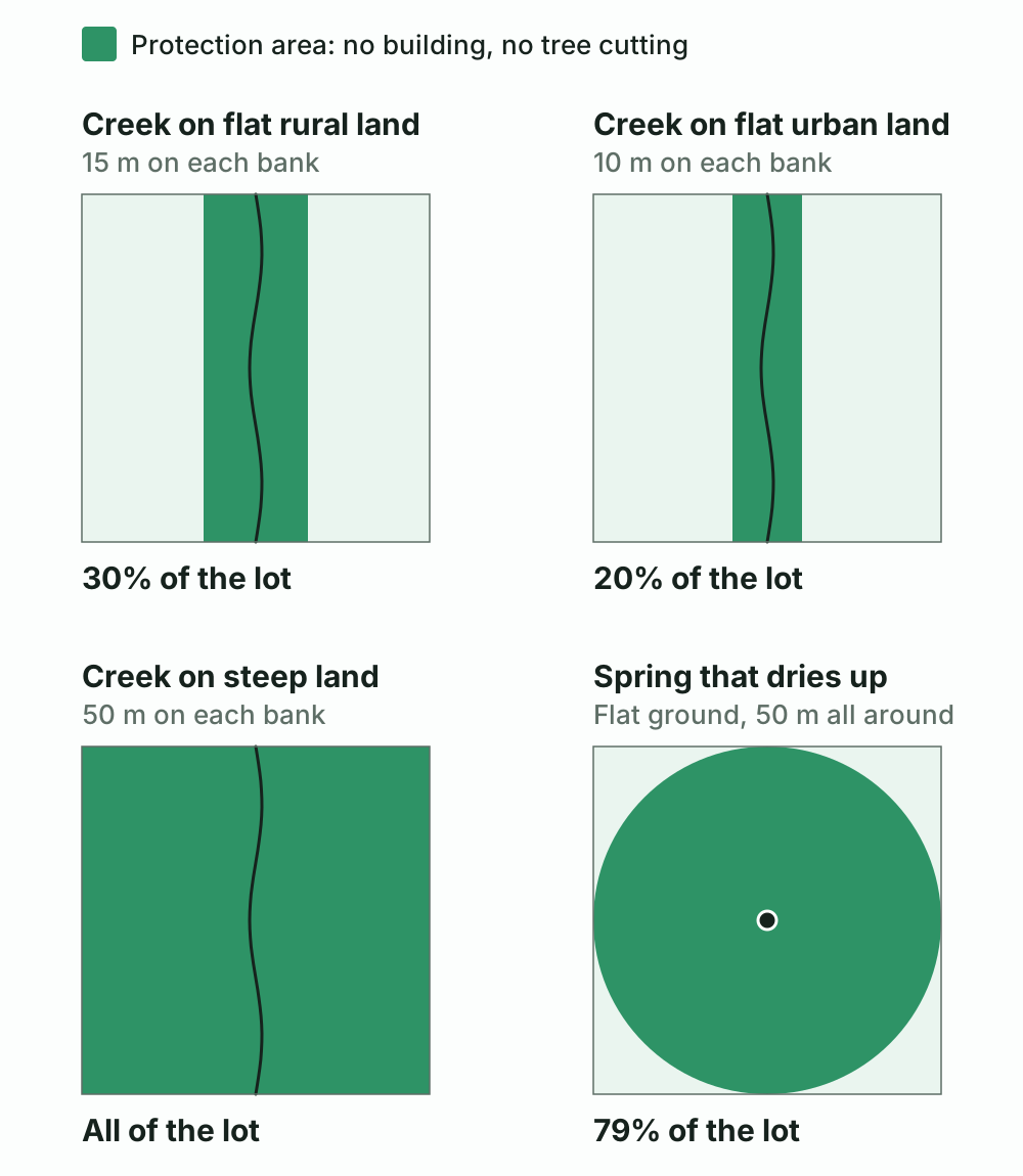
Protection areas drawn to scale on a lot of one hectare, 100 by 100 meters, with the creek or spring in the middle. A permanent spring's 100-meter circle would cover the whole lot. Source: references [2], [5] and [7].
Flood and landslide risk is mapped separately, and the hazard map article covers it.
Who decides where the strip runs on your lot
Three things decide where the strip runs, and a map cannot settle them: where the bank is, how steep the land is, and whether the area counts as urban. The forestry law gives the job to INVU, which issues an alineamiento, the official line that marks how close to the water you may build on a given lot.[8] INVU asks for the lot's plano catastrado, the registered survey plan, with three copies, plus a plan with contour lines for a subdivision or condominium. It answers within 30 business days, and the line is valid for a year.[9]
A method INVU published with the United Nations Development Programme in 2019 counts a creek as urban if it runs within 1,000 meters of the center of the nearest town, found by its public school, Catholic church and sports field. It treats any building in a strip as invading it, fences and water tanks included, even when the owner puts them up. Its maps are a reference only: to build next to a river, stream or creek, you still request the alignment for that lot.[10]
Forest on the lot, and when SINAC can allow a house
On land covered by forest, the forestry law bans changing the land's use, for example clearing it for farming or a tree plantation. SINAC, which acts as the State's forestry authority, can still permit a house, a road, a bridge or ecotourism facilities on private land where the forest stands. The cutting must be limited and proportional. Before any permit, the owner files a screening form, which decides whether an environmental impact assessment is needed.[11]
In law, a forest is native woodland of two hectares or more, with treetops covering more than 70% of the area and more than 60 trees per hectare at least 15 centimeters thick at chest height. Tree cover under two hectares counts as farmland without forest.[12]
Forest on land registered to the State, a municipality or another public body is part of the Patrimonio Natural del Estado, the State's natural heritage. It cannot be sold or seized, occupying it gives no rights however long it lasts, and it cannot be registered through a claim of possession.[13]
Land inside or next to a national park or refuge
National parks, biological reserves, wildlife refuges, forest reserves, protective zones and wetlands are created by law or decree, and their boundaries can take in private land. In a park, a biological reserve or a State wildlife refuge, the State is meant to buy or expropriate that land, and it becomes State land only once paid for. In a forest reserve, a protective zone, a wetland or a mixed wildlife refuge, the owner can keep the land by placing it under the forestry regime, a commitment recorded on the property. Until the State pays, an environmental plan applies in forest reserves, protective zones and refuges.[14]
Wildlife refuges are State, mixed or private. In a mixed or private refuge, developing the land or using its natural resources needs SINAC's authorization, based on an environmental impact assessment the owner pays for.[15] Wetlands, inside a protected area or not, cannot be drained, filled or dammed.[16]
Rules for the land around a protected area, its buffer zone or zona de amortiguamiento, come from the municipality or from the law that created the area. Since February 2020, Nicoya has applied its own to a strip 5 kilometers wide around the Ostional refuge, reaching Playa Nosara and Playa Guiones. New buildings there may cover at most 50% of the lot, counting pools and paved areas. They may be up to 9 meters tall in the first kilometer and on slopes seen from the beach, and 12 meters elsewhere, and they need a wastewater treatment system and outdoor lights that cannot be seen from the beach. A company that owns land there sued to annul the rules and lost; in June 2026 the Sala Primera, the Supreme Court's civil and administrative chamber, dismissed its final appeal.[17]
What the December 2025 ruling means for houses already built near water
Ley 10210 of 2022 let public bodies build bridges, culverts, intakes and drainage in rivers and their protection areas. It also opened the strips to "low impact" works for tourism, such as viewing platforms and zip lines. A transitional rule gave buildings already inside protection areas 24 months in which the State could not order them demolished. In that time, their owners were to get authorization under a regulation. The regulation was never issued, and the 24 months ended in June 2024.[18]
On December 17, 2025, the Sala Constitucional kept the public works and struck down the rest, including the transitional rule, by four votes to three. It found the rule would have shielded from demolition even buildings that could never be authorized. The ruling applies back to 2022. It says rights acquired in good faith are not affected, but it does not say what those are.[19]
So no law now offers a way to legalize a house, a fence or a tank built inside a protection area. Invading one is a crime under the forestry law, punishable by three months to three years in prison, on public or private land alike, and the builder has no right to compensation for what was built.[20]
What buyers can do before they commit
- Ask INVU for the alignment before you sign, or make the purchase conditional on it. It takes about six weeks and shows how wide the strip is on that lot and where it runs.
- Ask the municipality for a formal uso de suelo certificate, which often marks protection zones; the Cóbano sample in that article marks one for a well and a stream.
- Read the registry record. Many rural fincas carry reservas de ley, the statutory reserves for water and roads, among their registered entries. A commitment to the forestry regime, or a contract of payments for environmental services, is recorded there too; read its terms before you sign.
- Check whether the land lies inside or near a protected wild area. The Sistema Nacional de Información Territorial (SNIT), the government's map portal, publishes SINAC's map services, and the SINAC office for the region can answer questions. Near a refuge or park, ask the municipality whether it has buffer rules like Nicoya's.
- For land with trees, have a forestry professional say whether they meet the legal definition of forest. If they do, a house is still possible with SINAC's permit, and the forest can earn money: the Fondo Nacional de Financiamiento Forestal (FONAFIFO) pays owners to protect forest under five-year contracts, which it may extend for five more if it has the budget.[21]
- Price the lot by the area you can build on. The strip stays yours, as garden or woodland.
- Treat a building inside a strip as having no legal status. Do not buy it expecting to legalize it, and do not plan an extension toward the water. A Costa Rican lawyer can say what the good-faith exception might mean for a given property.
A PropScan report maps the rivers and streams from the national map against the parcel, estimates each protection strip at the 15-meter width for flat rural land, with the share of the lot it covers, and checks for SINAC protected areas within 50 meters. It notes that INVU's line is the official one. The linked sample is the Montezuma parcel above.
Common questions
How far from a river or creek can you build in Costa Rica?
Outside the protection area the forestry law sets along every river, stream and creek. On land with an average slope of 40% or less, it is 15 meters on each bank in rural areas and 10 meters in urban areas. On steeper land it is 50 meters. The strip is measured horizontally, and INVU, the national housing and urban planning institute, draws its exact line for a given lot.
Can you build near a spring in Costa Rica?
Not within 100 meters of a permanent spring, which the forestry law makes a protection area. Around a spring that dries up for part of the year, the water law bars cutting trees within 60 meters on a hillside or 50 meters on flat ground, and the attorney general's office reads it to mean bare ground there is replanted, not built on. Land within at least 200 meters of a point where drinking water is captured is reserved to the State.
Can a house built inside a river or spring protection area be legalized?
No law now offers a route. Ley 10210 of 2022 gave buildings already inside protection areas 24 months and a validation procedure, but the regulation it needed was never issued, and in December 2025 the Sala Constitucional, the Supreme Court's constitutional chamber, struck that rule down. Building in a protection area counts as invading it, a crime under the forestry law punishable by three months to three years in prison, and the builder has no right to compensation for what was built.
Can you build on forested land in Costa Rica?
The use of forested land cannot be changed, but SINAC, the national conservation agency, can permit a house, a road or ecotourism facilities in a privately owned forest, with limited and proportional tree cutting. The law counts tree cover as forest from two hectares, with a canopy over 70% of the area and more than 60 trees per hectare at least 15 centimeters thick at chest height.
Can you own land inside a national park or wildlife refuge in Costa Rica?
Land inside a national park, a biological reserve or a State wildlife refuge is meant to be bought or expropriated by the State, and it becomes State land only once paid for. In a forest reserve, a protective zone, a wetland or a mixed wildlife refuge, the State may also buy, but the owner can keep the land by placing it under the forestry regime, a commitment recorded on the property. Private refuges stay private. In mixed and private refuges, building or using natural resources needs the authorization of SINAC, the national conservation agency, and an environmental impact assessment.
Legal references and source notes
[1] PropScan's public sample report for concession 6-1881-Z-000 at Playa Las Manchas, Montezuma, compiled September 30, 2026. It finds an unnamed intermittent quebrada crossing the parcel for 145 m, whose 15 m strip on each side covers 4,193.13 m², 17.92% of the parcel, and a second one crossing it for 111 m; together the strips cover 6,706.12 m², 28.66% of the parcel. The water bodies come from the Instituto Geográfico Nacional's 1:25,000 hydrography on SNIT, and the strips use the width for flat rural land; the report notes that "the official alignment is issued by INVU". Source: PropScan sample report.
[2] Ley 7575, Ley Forestal, version 14 of 14, of March 25, 2026, art. 33: "Se declaran áreas de protección las siguientes: a) Las áreas que bordeen nacientes permanentes, definidas en un radio de cien metros medidos de modo horizontal. b) Una franja de quince metros en zona rural y de diez metros en zona urbana, medidas horizontalmente a ambos lados, en las riberas de los ríos, quebradas o arroyos, si el terreno es plano, y de cincuenta metros horizontales, si el terreno es quebrado. c) Una zona de cincuenta metros medida horizontalmente en las riberas de los lagos y embalses naturales y en los lagos o embalses artificiales construidos por el Estado y sus instituciones. Se exceptúan los lagos y embalses artificiales privados. d) Las áreas de recarga y los acuíferos de los manantiales, cuyos límites serán determinados por los órganos competentes establecidos en el reglamento de esta ley." Art. 34: "Se prohíbe la corta o eliminación de árboles en las áreas de protección descritas en el artículo anterior, excepto en proyectos declarados por el Poder Ejecutivo como de conveniencia nacional." Art. 58(a) punishes whoever "Invada un área de conservación o protección" (see note 20). Source: Ley 7575, PGR-SINALEVI.
[3] Sala Constitucional, voto 2025-041905 of December 17, 2025, quoting the PGR: "las áreas de protección constituyen limitaciones legítimas al derecho de propiedad privada que tienen como finalidad proteger y conservar el recurso hídrico contra acciones humanas que puedan degradar el estado natural de las fuentes de agua, preservar o regenerar la cobertura forestal aledaña a los cuerpos de agua". Source: Poder Judicial, Nexus.
[4] Ley 6043, Ley sobre la Zona Marítimo Terrestre, version 9 of 9. Art. 1: the zone "pertenece al Estado y es inalienable e imprescriptible". Art. 9: "Zona marítimo terrestre es la franja de doscientos metros de ancho a todo lo largo de los litorales Atlántico y Pacífico de la República, cualquiera que sea su naturaleza, medidos horizontalmente a partir de la línea de la pleamar ordinaria". Source: Ley 6043, PGR-SINALEVI.
[5] Ley 276, Ley de Aguas, version 4 of 4, art. 149: "Se prohibe destruir, tanto en los bosques nacionales como en los de particulares, los árboles situados a menos de sesenta metros de los manantiales que nazcan en los cerros, o a menos de cincuenta metros de los que nazcan en terrenos planos." Art. 148 requires owners whose stream or spring banks have lost their forest to plant trees along them. PGR, dictamen C-318-2017 of December 19, 2017, to the Municipalidad de Puriscal: art. 149 "no distingue entre manantiales permanentes o intermitentes"; and "en el supuesto de terrenos desprovistos de masa arbórea, no se suprime la tutela del recurso forestal, más bien se genera la obligación de reforestar frente a la inexistencia de árboles, en lugar de construir en ese espacio, según los numerales 148 y 149 de la Ley de Aguas." Sources: Ley 276, PGR-SINALEVI, PGR, C-318-2017.
[6] Ley 276, Ley de Aguas, art. 31: "Se declaran como reserva de dominio a favor de la Nación: a) Las tierras que circunden los sitios de captación o tomas surtidoras de agua potable, en un perímetro no menor de doscientos metros de radio". Source: Ley 276, PGR-SINALEVI.
[7] Decreto 25721-MINAE, Reglamento a la Ley Forestal, version 28 of 28, of July 30, 2024, art. 2(v): "Terrenos quebrados: Son aquellos que tienen una pendiente promedio superior al cuarenta por ciento (40%)." Source: Decreto 25721, PGR-SINALEVI.
[8] Ley 7575, art. 34: "Los alineamientos que deban tramitarse en relación con estas áreas, serán realizados por el Instituto Nacional de Vivienda y Urbanismo." Source: Ley 7575, PGR-SINALEVI.
[9] INVU, "Alineamientos de ríos, quebradas, etc." (alineamiento fluvial), in the government's Catálogo Nacional de Trámites, read October 13, 2026: requirements "Plano de catastro original o copia certificada sin reducir, Tres copias del plano catastrado sin reducir", a plan "con curvas de nivel" for urbanizations and condominiums, and payment of the Dirección de Urbanismo's fee; resolution period 30 business days; validity one year; filed in person. Source: Catálogo Nacional de Trámites, procedure 596.
[10] INVU and the United Nations Development Programme, Metodología para la delimitación digital de las áreas de protección de ríos, quebradas y arroyos, November 2019. The urban test: identify the nearest town by "al menos una escuela pública, un templo católico, plaza de deportes", draw "un círculo con un radio de 1000 metros" from their center, and a stream inside it "se cataloga como zona urbana"; outside, "se cataloga como rural". The digital map "no sustituye la necesidad de cumplir con el requisito de solicitar el alineamiento fluvial al INVU, predio por predio, para construcción, ampliación o ejecución de cualquier tipo de actividad o infraestructura, en terrenos colindantes con ríos, quebradas o arroyos". Its glossary defines invasion as including "todos aquellos actos - aunque sean cometidos por la persona dueña del terreno - que impliquen construcción de cualquier tipo de edificaciones sobre las áreas de protección, como por ejemplo cercas, tanques o casas". INVU's own site does not serve the document to automated requests; this is the copy that was read. Source: the methodology, PDF.
[11] Ley 7575, art. 19: "En terrenos cubiertos de bosque, no se permitirá cambiar el uso del suelo, ni establecer plantaciones forestales. Sin embargo, la Administración Forestal del Estado podrá otorgar permiso en esas áreas para los siguientes fines: a) Construir casas de habitación, oficinas, establos, corrales, viveros, caminos, puentes e instalaciones destinadas a la recreación, el ecoturismo y otras mejoras análogas en terrenos y fincas de dominio privado donde se localicen los bosques." The cutting "será limitada, proporcional y razonable", and "Previamente, deberá llenarse un cuestionario de preselección ante la Administración Forestal del Estado para determinar la posibilidad de exigir una evaluación del impacto ambiental". SINAC is the Administración Forestal del Estado: Ley 7788, Ley de Biodiversidad, version 7 of 7, art. 22, provides that "la Dirección General de Vida Silvestre, la Administración Forestal del Estado y el Servicio de Parques Nacionales ejercerán sus funciones y competencias como una sola instancia, mediante la estructura administrativa del Sistema". Sources: Ley 7575, PGR-SINALEVI, Ley 7788, PGR-SINALEVI.
[12] Ley 7575, art. 3(d): a forest is a native ecosystem "que ocupa una superficie de dos o más hectáreas, caracterizada por la presencia de árboles maduros de diferentes edades, especies y porte variado, con uno o más doseles que cubran más del setenta por ciento (70%) de esa superficie y donde existan más de sesenta árboles por hectárea de quince o más centímetros de diámetro medido a la altura del pecho (DAP)". Decreto 25721-MINAE, art. 2(w), as reformed by Decreto 38769 of 2014: "Terrenos de uso agropecuario y sin bosque" include "fincas que tienen áreas con cobertura boscosa menores a dos hectáreas". Sources: Ley 7575, PGR-SINALEVI, Decreto 25721, PGR-SINALEVI.
[13] Ley 7575, art. 13: the Patrimonio Natural del Estado is made up of "los bosques y terrenos forestales de las reservas nacionales, de las áreas declaradas inalienables, de las fincas inscritas a su nombre y de las pertenecientes a municipalidades, instituciones autónomas y demás organismos de la Administración Pública". Art. 14: these lands "serán inembargables e inalienables; su posesión por los particulares no causará derecho alguno a su favor y la acción reivindicatoria del Estado por estos terrenos es imprescriptible. En consecuencia, no pueden inscribirse en el Registro Público mediante información posesoria". Source: Ley 7575, PGR-SINALEVI.
[14] Ley 7554, Ley Orgánica del Ambiente, version 14 of 14, of August 26, 2026. Art. 32, as reformed by Ley 10963 of June 22, 2026, lists the categories: "a) Reservas forestales. b) Zonas protectoras. c) Parques nacionales. d) Reservas biológicas. e) Refugios nacionales de vida silvestre. f) Humedales. g) Monumentos naturales. h) Paisajes nacionales." Art. 37 lets the Executive include "las fincas o partes de fincas particulares necesarias"; "Cuando se trate de parques nacionales, reservas biológicas o refugios nacionales de vida silvestre estatales, los terrenos serán adquiridos por compra, expropiación o ambos procedimientos, previa indemnización. En los casos de reservas forestales, zonas protectoras, refugios de vida silvestre mixtos y humedales, los predios o sus partes también podrán comprarse o expropiarse, salvo que, por requerimiento del propietario, se sometan voluntariamente al régimen forestal. Esa sujeción será inscrita en el Registro Público de la Propiedad, como una afectación al inmueble". Private fincas "quedarán comprendidas dentro de las áreas protegidas estatales solo a partir del momento en que se hayan pagado o expropiado legalmente", and in forest reserves, protective zones and refuges, until payment, "las áreas quedarán sometidas a un plan de ordenamiento ambiental que incluye la evaluación de impacto ambiental". Source: Ley 7554, PGR-SINALEVI.
[15] Ley 7317, Ley de Conservación de la Vida Silvestre, version 17 of 17, art. 82, as reformed by Ley 9106 of 2012: "existen tres clases de refugios nacionales de vida silvestre: a) Refugios de propiedad estatal. b) Refugios de propiedad mixta. c) Refugios de propiedad privada." Projects "de desarrollo y de explotación de los recursos naturales, comprendidos en los refugios de tipo b y c, requerirán de la autorización del Sistema Nacional de Áreas de Conservación", analyzed on "una evaluación de impacto de la acción por desarrollar ... costeada por el interesado". Source: Ley 7317, PGR-SINALEVI.
[16] Ley 7554, art. 41: wetlands are of public interest "estén o no estén protegidos por las leyes que rijan esta materia". Art. 45: "Se prohíben las actividades orientadas a interrumpir los ciclos naturales de los ecosistemas de humedal, como la construcción de diques que eviten el flujo de aguas marinas o continentales, drenajes, desecamiento, relleno o cualquier otra alteración que provoque el deterioro y la eliminación de tales ecosistemas." Source: Ley 7554, PGR-SINALEVI.
[17] Municipalidad de Nicoya, Reglamento para el otorgamiento de permisos de construcción en la zona de amortiguamiento del Refugio Nacional de Vida Silvestre Ostional, La Gaceta 40 of February 28, 2020, pp. 54 to 56. Art. 3: the buffer "comprende cinco kilómetros desde el límite externo del Refugio hacia el continente". Art. 4(4): the direct-impact area is the "Primer kilómetro ... más las pendientes orientadas hacia el mar visibles desde la playa". Art. 4(6) counts pools and paved areas as coverage. Art. 5: "una cobertura máxima de un 50% del área total de lote". Art. 6: height "no debe sobrepasar los nueve metros" in the direct-impact area and "doce metros" in the rest. Art. 7: outdoor light sources must not be "directamente visible desde la playa". Art. 9: every new building needs a wastewater treatment system. Sala Primera, resolución 000725-F-S1-2026 of June 4, 2026, file 20-002115-1027-CA: "Se declara sin lugar el recurso" against the Tribunal Contencioso Administrativo's sentencia 2023004296, which had rejected the suit to annul the regulation. Sources: La Gaceta 40, 2020, Poder Judicial, Nexus.
[18] Ley 10210 of May 5, 2022, La Gaceta 101 of June 1, 2022, added arts. 33 bis and 33 ter to the Ley Forestal. Art. 33 bis, second paragraph, as enacted: "se autorizan obras de bajo impacto ambiental tales como plataformas de observación, puentes, puentes colgantes, tirolesas, elementos de señalización". Transitorio II, as enacted: "Por el plazo de veinticuatro meses, contado a partir de la entrada en vigencia de la presente ley, aquellas obras existentes que se encuentren dentro de la zona de protección podrán mantenerse sin que se pueda ordenar, por parte del Estado, su derribo y/o eliminación. En dicho plazo, las personas físicas o jurídicas deberán obtener la autorización respectiva y validar las construcciones existentes de acuerdo con la reglamentación emitida para tales efectos." Transitorio I gave MINAE three months to issue the regulation; the Sala Constitucional's ruling (note 19) records that the validation procedure was never applied. The enacted text is version 1 of 2 on SINALEVI. Source: Ley 10210, PGR-SINALEVI.
[19] Sala Constitucional, voto 2025-041905 of December 17, 2025, file 23-002032-0007-CO, published in full in the Boletín Judicial of April 8, 2026: "1) Por unanimidad, se declara sin lugar la acción en cuanto al primer párrafo del numeral 33 bis. 2) Por mayoría, se declara CON lugar la acción en contra del segundo párrafo del artículo 33 bis y el artículo 33 ter de la Ley Forestal, así como el transitorio II de la ley nro. 10210. 3) Por mayoría, se interpreta el último párrafo del artículo 33 bis de la Ley Forestal, en el sentido de que la competencia de la Dirección de Agua de otorgar las autorizaciones previstas, no desconoce la exigencia de rango constitucional y convencional de contar con una evaluación de impacto ambiental previa, cuando, dependiendo de la obra o actividad correspondiente, técnicamente así se requiera, en concordancia con las competencias de la SETENA en esa materia. Esta sentencia tiene efectos declarativos y retroactivos a la fecha de vigencia de las normas anuladas, sin perjuicio de derechos adquiridos de buena fe." Three justices dissented in part. On the transitional rule, the ruling says that under it "cualquier construcción ilegal que se encuentre en un área de protección no puede ser demolida, aunque se trate de una obra no contemplada en los supuestos regulados en los artículos 33 bis y 33 ter y que, por ello, no podría regularizarse". Source: Poder Judicial, Nexus.
[20] Ley 7575, art. 58: "Se impondrá prisión de tres meses a tres años a quien: a) Invada un área de conservación o protección, cualquiera que sea su categoría de manejo, u otras áreas de bosques o terrenos sometidos al régimen forestal, cualquiera que sea el área ocupada; independientemente de que se trate de terrenos privados del Estado u otros organismos de la Administración Pública o de terrenos de dominio particular. Los autores o partícipes del acto no tendrán derecho a indemnización alguna por cualquier construcción u obra que hayan realizado en los terrenos invadidos." Source: Ley 7575, PGR-SINALEVI.
[21] Decreto 25721-MINAE, art. 116, added by Decreto 44607 of July 30, 2024: "El plazo de los contratos de servicios ambientales o Ecosistémicos de la actividad de protección de bosques será de cinco años, pudiendo ser prorrogados por un periodo igual, siempre y cuando el Fondo Nacional de Financiamiento Forestal así lo determine y exista presupuesto". Art. 117: MINAE sets "los montos a pagar por cada uno de los servicios ambientales" by resolution each year. The contracts are recorded on the property as an afectación (arts. 59 and 119). Source: Decreto 25721, PGR-SINALEVI.
This guide is informational and not a substitute for legal advice. For a purchase, work with an experienced attorney or notary.